


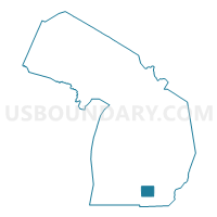
Jackson County PUMA, Michigan
About
Outline

Summary
| Unique Area Identifier | 193175 |
| Name | Jackson County PUMA |
| State | Michigan |
| Area (square miles) | 723.50 |
| Land Area (square miles) | 701.67 |
| Water Area (square miles) | 21.83 |
| % of Land Area | 96.98 |
| % of Water Area | 3.02 |
| Latitude of the Internal Point | 42.24847380 |
| Longtitude of the Internal Point | -84.42086790 |
Maps

Graphs
Select a template below for downloading or customizing gragh for Jackson County PUMA, Michigan


Neighbors
Neighoring Public Use Microdata Area (by Name) Neighboring Public Use Microdata Area on the Map
- Calhoun & Barry Counties PUMA, MI
- Eaton & Clinton Counties PUMA, MI
- Ingham County (South & East) PUMA, MI
- Lenawee & Hillsdale Counties PUMA, MI
- Livingston County PUMA, MI
- Washtenaw County (West, Northeast & Southeast) PUMA, MI
Top 10 Neighboring County (by Population) Neighboring County on the Map
- Washtenaw County, MI (344,791)
- Ingham County, MI (280,895)
- Livingston County, MI (180,967)
- Jackson County, MI (160,248)
- Calhoun County, MI (136,146)
- Eaton County, MI (107,759)
- Lenawee County, MI (99,892)
- Hillsdale County, MI (46,688)
Top 10 Neighboring County Subdivision (by Population) Neighboring County Subdivision on the Map
- Jackson city, Jackson County, MI (33,534)
- Blackman charter township, Jackson County, MI (24,051)
- Summit township, Jackson County, MI (22,508)
- Leoni township, Jackson County, MI (13,807)
- Spring Arbor township, Jackson County, MI (8,267)
- Columbia township, Jackson County, MI (7,420)
- Napoleon township, Jackson County, MI (6,776)
- Cambridge township, Lenawee County, MI (5,733)
- Grass Lake charter township, Jackson County, MI (5,684)
- Henrietta township, Jackson County, MI (4,705)
Top 10 Neighboring Place (by Population) Neighboring Place on the Map
- Jackson city, MI (33,534)
- Vandercook Lake CDP, MI (4,721)
- Michigan Center CDP, MI (4,672)
- Spring Arbor CDP, MI (2,881)
- Napoleon CDP, MI (1,258)
- Brooklyn village, MI (1,206)
- Grass Lake village, MI (1,173)
- Concord village, MI (1,050)
- Vineyard Lake CDP, MI (980)
- Springport village, MI (800)
Top 10 Neighboring Unified School District (by Population) Neighboring Unified School District on the Map
- Jackson Public Schools, MI (55,321)
- Northwest School District, MI (26,543)
- Eaton Rapids Public Schools, MI (17,112)
- Chelsea School District, MI (15,720)
- Western School District, MI (12,900)
- Albion Public Schools, MI (11,840)
- Columbia School District, MI (11,469)
- Stockbridge Community Schools, MI (10,235)
- Onsted Community Schools, MI (9,400)
- Napoleon Community Schools, MI (8,536)
Top 10 Neighboring State Legislative District Lower Chamber (by Population) Neighboring State Legislative District Lower Chamber on the Map
- State House District 52, MI (104,679)
- State House District 67, MI (100,145)
- State House District 47, MI (96,487)
- State House District 57, MI (94,159)
- State House District 62, MI (93,343)
- State House District 58, MI (91,936)
- State House District 65, MI (89,787)
- State House District 64, MI (86,288)
Top 10 Neighboring State Legislative District Upper Chamber (by Population) Neighboring State Legislative District Upper Chamber on the Map
- State Senate District 24, MI (278,340)
- State Senate District 18, MI (274,505)
- State Senate District 22, MI (273,659)
- State Senate District 17, MI (267,269)
- State Senate District 23, MI (258,851)
- State Senate District 16, MI (253,123)
- State Senate District 19, MI (251,432)
Top 10 Neighboring 111th Congressional District (by Population) Neighboring 111th Congressional District on the Map
Top 10 Neighboring Census Tract (by Population) Neighboring Census Tract on the Map
- Census Tract 64.02, Jackson County, MI (6,995)
- Census Tract 56, Jackson County, MI (6,782)
- Census Tract 58, Jackson County, MI (6,776)
- Census Tract 62, Jackson County, MI (6,776)
- Census Tract 60, Jackson County, MI (6,764)
- Census Tract 65, Jackson County, MI (6,710)
- Census Tract 61, Jackson County, MI (6,567)
- Census Tract 52, Jackson County, MI (6,566)
- Census Tract 54, Jackson County, MI (6,542)
- Census Tract 68.04, Jackson County, MI (5,641)
Top 10 Neighboring 5-Digit ZIP Code Tabulation Area (by Population) Neighboring 5-Digit ZIP Code Tabulation Area on the Map
- 49201, MI (45,190)
- 49203, MI (38,280)
- 49202, MI (20,661)
- 48827, MI (15,971)
- 49224, MI (14,224)
- 48118, MI (12,552)
- 49230, MI (10,475)
- 49240, MI (8,703)
- 48158, MI (7,309)
- 49251, MI (6,229)